Port Republic Road/Peach Grove/Neff Avenue Small Area Study
Introduction to the Study
The Harrisonburg Rockingham Metropolitan Planning Organization (HRMPO) and the City of Harrisonburg, in coordination with the Virginia Department of Transportation (VDOT), are conducting a transportation study focused on the Port Republic Road corridor and its intersections with Peach Grove Avenue and Neff Avenue.
This area experiences significant safety and operational challenges that will be exacerbated by planned growth. From 2019-2023, the area had 148 crashes, with 56% involving young drivers aged 15-21. Current traffic operations show significant congestion during PM rush hours, with drivers experiencing substantial delays and long vehicle queues at key intersections. Traffic analysis indicates these conditions will worsen as development continues in the area without appropriate infrastructure improvements.
This study will create a holistic plan for accommodating travel under short- and long-term build-out scenarios, addressing current operational and safety needs while preparing for future development. The study has identified various improvement alternatives to address these issues, ranging from pedestrian and bicycle facility enhancements to significant intersection modifications. Your feedback on these proposed solutions is valuable as we move toward selecting preferred alternatives and developing an implementation plan.

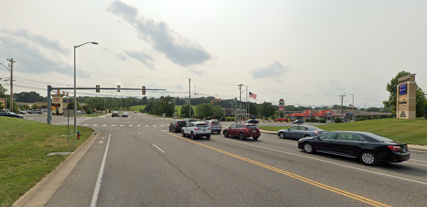
View from the Neff Avenue approach to the Port Republic Rd./Peach Grove Ave./ Neff Ave. Intersection.
Study Area
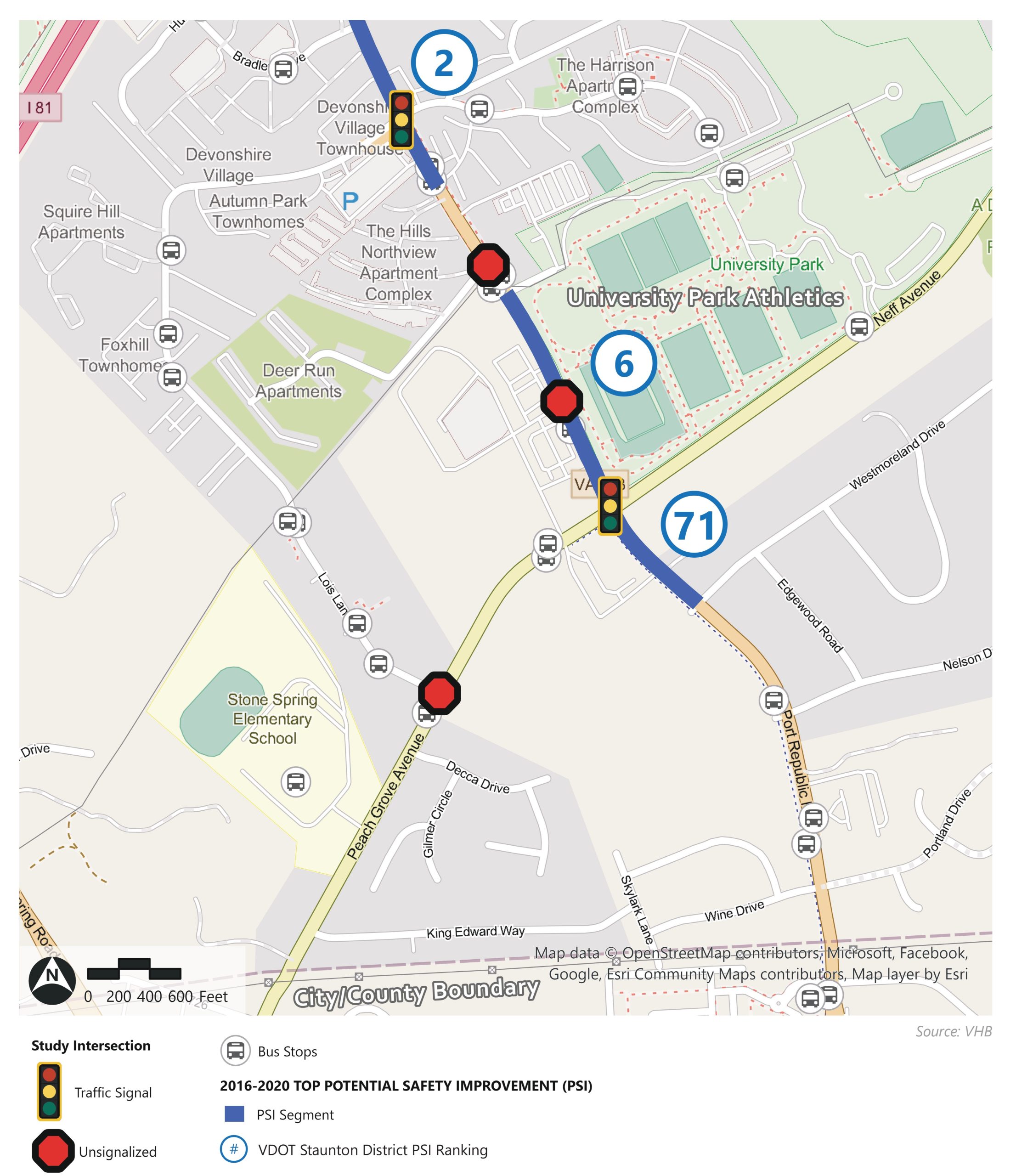
Map of the study area, which includes the area bounded by Devon Lane to the north/west, Portland/Wine Drive to the south/east, Turner Ashby Lane/A Dream Come True Playground to the north/east, and Stone Spring Road to the south/west.
The study area encompasses the Port Republic Road corridor from Devon Lane in the north to Stone Spring Road in the south, including the major intersections at Peach Grove Avenue/Neff Avenue and Devon Lane. The image shows the existing transportation network with signalized and unsignalized intersections and bus stop locations throughout the corridor.
This area serves as a vital connection between James Madison University, residential neighborhoods, and commercial districts, with high volumes of vehicle, pedestrian, and bicycle traffic.
Existing Safety and Operational Conditions
The road network of Port Republic Rd., Peach Grove Ave., and Neff Ave. in the Study Area represent significant safety and operational challenges.
The Port Republic Road/Neff Avenue/Peach Grove Avenue intersection presents significant safety challenges:
- Potential for Safety Improvement (PSI) is a crash metric indicative of a location having more crashes than would be expected based on characteristics such as roadway geometry and traffic volume
- Segments of Port Republic Road within the study area have some of the highest PSI values in VDOT’s Staunton District
- The Port Republic Road/Neff Avenue/Peach Grove Avenue intersection has the highest PSI within the Harrisonburg Rockingham MPO
Current operational issues include excessive queue lengths (520ft on Peach Grove, 750ft at Devon Lane) and limited multimodal connectivity with significant pedestrian safety risks.
Future Growth Considerations
There is significant growth both that has been approved and that is planned for along and within the corridor.
Future development will intensify transportation demands in this area:
- Significant residential and commercial development is planned for the study area, particularly concentrated around the Port Republic Road/Neff Avenue/Peach Grove Avenue intersection and areas to the south in the Stone Spring Urban Development Area
- The corresponding traffic growth will result in constrained, multimodal transportation conditions within the study area, particularly around the Port Republic Road/Neff Avenue/Peach Grove Avenue intersection
Traffic forecasting for 2045 conditions uses growth rates of 2% and 0.75% for different segments, resulting in projected Average Daily Traffic (ADT) increases of:
- Port Republic Road north of Devon: 21,700 ADT (2024) → 25,000 ADT (2045)
- Port Republic Road south of Peach Grove: 15,900 ADT (2024) → 22,600 ADT (2045)
- Peach Grove Avenue: 10,600 ADT (2024) → 15,000 ADT (2045)
These projections highlight the need for comprehensive transportation improvements to accommodate future growth while maintaining safety and efficiency.
Review the Final Study Report
The final study report provides a framework for:
- Study recommendations for future implementation
- Preferred alternatives for transportation improvements
The City will adopt the plan and incorporate it by reference into the Comprehensive Plan, giving City staff the tools needed to collaborate with developers on increasing capacity, travel options, and preserving safety for the transportation network in this high-traffic area.

Map of the study area, which includes the area bounded by Devon Lane to the north/west, Portland/Wine Drive to the south/east, Turner Ashby Lane/A Dream Come True Playground to the north/east, and Stone Spring Road to the south/west.

The road network of Port Republic Rd., Peach Grove Ave., and Neff Ave. in the Study Area represent significant safety and operational challenges.

Map of existing and planned development along with the growth of Average Daily Traffic (ADT) increased growth that is estimated by 2045
